ELEVATION OF A KITE |
|
|
|
HYPOTHENUSE CALCULATION
A simple formula:
|
|
|
|
|
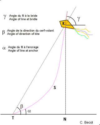
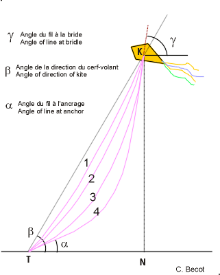
THE LINE IS CURVED Some kiters are guessing that this is too much approximate because the line is curved. In fact it is difficult to know exactly the true curve of the line. I have observed that there are two angles which could be measured with the astrolabe and give a better clue of the curve of the line. These are the line angle "alpha" at the anchoring place and the line angle "gamma"at the bridle. With these angles I have been able to define new calculation methods which provide more close results. Another consideration should be the elongation of the line under tension which is ranging from 1% to 5% depending on the line and the stress. |
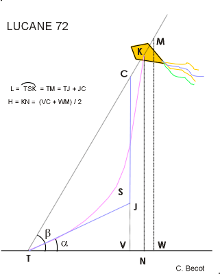
LUCANE 72 METHOD This method was published in Le Lucane magazine n° 72 of the Cerf-Volant Club de France in June 1995. Its principle is that the true elevation KN of the curved line TSK is between the line considered as straight TM (elevation MW) and the line considered as two segments TJ and JC (elevation CV). The formula is that the elevation is the average between the two extreme elevations. The result is not too bad. The comparison with other methods shows that shifting a little the average would give a more accurate result. This method shows that the two extreme elevations are in fact not much different. Calculation as for the hypothenuse and alpha = 55° gives a calculated elevation of 88,9m |
|
|
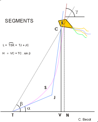
THE SEGMENTS METHOD This method is considering the line as two segments which are defined from the line angles at the anchor and at the bridle. As seen on the drawing, the calculated elevation is always lower than the true elevation. However the accuracy is fair when the line is moderately curved. Calculation as previous example , 100m length line, kite elevation angle beta = 65°, line angle at anchor alpha = 55° and line angle at bridle gamma = 70° gives a calculated kite elevation of 89,9 m. |
|
|
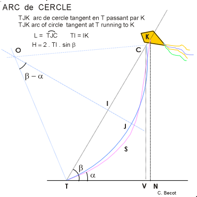
THE ARC METHOD This method is also based on the angles of the line at the anchor and at the bridle. now the line is considered as a circle which is tangent to the line at the anchor and at the bridle. It seems that it is the draw which is the closer to the true curve of the line. As with the same examples than other methods, the calculated elevation is 90,2 m. It is interesting to remark that apart the hypothenuse method which is also the maximum elevation with a line absolutely straight, the calculated elevation of the arc method is the highest value in this example. If the Lucane method was set as the average of the hypothenuse and the segment method, as maximum and minimum elevation, result would be 90.25m |
|
|
|
|
CONCLUSION
Only if geotagging or photogrammetry of images is done, an accurate elevation is necessary. In this case, an altimeter combined with the camera is the only way to get accurate results if properly used and calibrated |